Anyone who has driven through Washington D.C. can probably tell a personal horror story about the city’s numerous traffic circles. Tourists frequently get caught in DuPont Circle, destined to make multiple trips around the central fountain erected by Admiral Francis Du Pont, the Mexican-American War hero who captured San Diego.
Note. The biggest problem with driving in the
capital seems to be the large number of cabs driven by people who apparently
have arrived in the country the previous week and have only a rudimentary
understanding of either the city or our traffic laws. A couple of years ago, I caught a yellow cab
and asked to be taken to the Argentine Embassy.
When the driver said he didn’t
know the address, I told him to just go to the White House and I would direct
him from there. To which the cabbie
answered, “The White House?
Where’s
that?”
If you haven’t
been to the capital, the city is laid out in a grid with streets named after
letters running East/West, and streets running north/South named after
numbers. To this perfectly
understandable system, wide thoroughfares running at strange diagonals
crisscross the city and wherever two of these avenues cross, there are multi-lane
traffic circles with cars circling counter clockwise endlessly searching for
the exit they just passed.
Note. Traffic circles are all the rage right now
with city planners. There is ample
evidence that traffic circles move vehicles through an intersection faster than
traffic lights and result in fewer traffic fatalities. What the city planners never say is that,
while fatal accidents
decrease because colliding cars hit at a slight angle, the frequency of these
non-fatal accidents actually increase.
And with traffic circles with numerous lanes, that increase is dramatic.
With a few modifications, the city plan was laid out by Pierre
Charles L'Enfant, an associate of Lafayette who served on General Washington’s staff during the
American Revolution. After the war,
President Washington gave L’Enfant
the task of drawing up the plans for the new capital which was at that time
being called ‘Federal
City’. Far exceeding his directive to come up with a
city plan, L’Enfant
took it upon himself to help fix the location of the city, design the city plan,
secure leases at quarries for stone, and even specify the size of the
government buildings. His design for the
‘President’s Palace’, for example, was for
a residence five times the size of the current building. In today’s
world of mega-mansions, that doesn’t
sound that impressive, but when the Executive Mansion was finally
constructed—it wasn’t
called the White House until the 20th century—it was the largest
American residence in history.
The Federal District was to be a square rotated 45°, ten miles to a side, straddling the
Potomac River and more or less equally located on land ceded by Maryland and
Virginia. This location was a compromise
between the northern location desired by Alexander Hamilton and a Southern site
that Thomas Jefferson wanted. (And yes,
the basis of the argument was slavery.
If George Washington, a Virginian, had not been president when the
Resident Act was finally passed, the site would probably have been farther to
the north.)

A much larger problem for this myth is the fact that L’Enfant did not
design circles at the intersections, but large rectangles. And inside each of the rectangles, L’Enfant planned for
each state to set up an informal embassy representing their economic
interests. The senators and
representatives from each state would build their homes around these plazas,
developing little communities that promoted the commerce and culture of their
states. In the center of the rectangles
would be fountains and statues erected by the state honoring their
distinguished citizens and historic events.
L’Enfant
positioned each of the public squares within sight of at least two other
squares, promoting a sense of unity and cooperation between the states. Unfortunately, this plan for a city to emerge
from a collection of ‘walking
communities’ was
never realized, as none of the states expended any money or any tangible effort
to establish any kind of presence within their squares. Over the years, most of the land originally
inside the squares came to be owned privately.
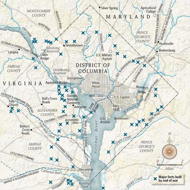
Obviously, the Union had to build fortifications to defend the
nation’s
capital. Ignoring the various circles,
the Union Army built 68 forts, 93 artillery batteries with 807 cannons, 13
miles of rifle trenches, and 32 miles of military roads linking the
fortifications. Not a single one of
these fortifications involved one of the squares/circles. (The X’s
on the map indicate the location of the forts.)
The proof of the effectiveness of the forts came in June 1864
after General Grant moved many of the seasoned troops out of Washington to
replace the troops he had lost chasing General Lee. As the forts were now manned by new recruits
and men recovering from battle wounds, Lee saw an opportunity to strike the
Union capital, and sent General Jubal Early and his army to capture the
city. The battle raged for several days
and the Confederates penetrated the outer defenses as far as the present site
of Walter Reed Medical Center before General Early conceded that the Union
defenses were simply too formidable to continue the attack. The fighting never got close to the inner
city.
During the battle, President Lincoln came to observe the battle
personally. The tall president was
easily recognizable—standing on a parapet, wearing his customary stovepipe
hat. A Confederate sharpshooter fired a
round at Lincoln, striking a surgeon standing next to the president. So far, Lincoln is the only serving US
president to have been shot at during a battle.
One last point. When Lincoln was shot at, a Union officer yelled, “Get down, you fool!” I’ve always thought that advice should be given to every president.
The best laid plans o' mice and men, oftimes gang agly.
ReplyDeleteWell, that's what Robert said.
Delete